
Weather markets settle one day at a time, but the weather does not start from scratch every morning. Larger climate patterns can change the types of weather setups that show up more often over an entire season. This winter, one of the biggest patterns to watch is El Niño.
El Niño happens when the tropical Pacific becomes unusually warm and changes the way air moves around the atmosphere. For the United States, one of the biggest effects is a shift in the jet stream, which acts like a highway for storms. During many El Niño winters, that storm track favors a more active path across the southern United States.
This year could be especially interesting. NOAA said in September that El Niño was strengthening, with a greater than 90% chance of a very strong event during fall and winter 2026-27. That does not guarantee extreme weather everywhere, but it gives the atmosphere a stronger El Niño signal to work with.
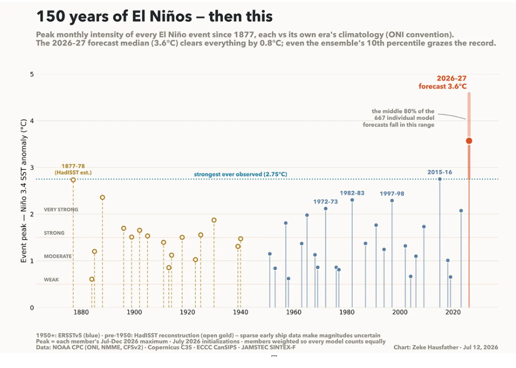
The historical comparison below shows why this event has received so much attention. A July 2026 multi-model compilation put the median projected peak Niño 3.4 anomaly near 3.6°C, above the strongest observed event shown at about 2.75°C. The range is wide, so that forecast is not a guaranteed outcome. It simply shows how unusually strong some models believed this event could become.
150 Years of El Niño Events - Historical Context vs. the 2026-27 Forecast
When Could the Biggest Effects Show Up?
El Niño does not switch on overnight. Its influence develops over time. Forecasts strengthened through summer, confidence was extremely high by September, and winter is the main period when the U.S. weather pattern is most likely to reflect El Niño.
El Niño Timeline - What to Watch in 2026-27
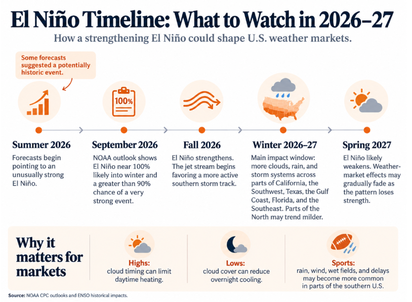
The timeline shows the progression. Summer forecasts began pointing toward an unusually strong event. By September, NOAA was showing El Niño near 100% likely into winter and a greater than 90% chance of a very strong event. During fall, the pattern strengthens, and winter becomes the main window for a more active southern storm track.
The same pattern can matter differently across markets. More cloud cover can limit daytime heating in high-temperature markets, while clouds can reduce overnight cooling in low-temperature markets. A wetter southern pattern can also bring more rain, wind, wet fields, and possible delays to outdoor sporting events.
Which Regions Could Be Affected Most?
The southern United States is probably the most important region to watch. El Niño winters often favor a stronger southern storm track, bringing more clouds and precipitation across California, the Southwest, Texas, the Gulf Coast, Florida, and the Southeast.
For temperature markets, cloud timing may be one of the biggest variables. If Dallas is forecast to reach 64°F, clearing at 9 AM leaves much more time for heating than clearing at 1 PM. El Niño does not tell you which outcome will happen, but it can create more days where cloud timing matters.
California, Las Vegas, and Phoenix can become more sensitive to Pacific storms, while Dallas, Houston, San Antonio, and New Orleans can react quickly to changes in clouds and rain. Florida and the Southeast may also see a stronger wet-weather signal. More clouds can limit afternoon heating and sometimes slow overnight cooling. The northern tier often gets a different setup, with parts of the North experiencing a milder winter background. Major cold outbreaks can still happen. El Niño changes probabilities, not guarantees.
What Could This Mean for Weather Markets?
The easiest mistake would be saying, 'El Niño means this city will be colder tomorrow.' A better question is whether El Niño makes the type of weather that causes forecast misses more common. If models struggle when clouds clear later than expected, a winter with more stormy setups could make that weakness matter more often.
El Niño is not a direct trading signal. It is context. Miami lows may behave differently when clouds limit overnight cooling, Los Angeles highs may become more sensitive to Pacific storms, and northern cities may start from a milder seasonal background.
What About Sporting Events?
Outdoor sports could feel the effects most across California, Texas, the Gulf Coast, Florida, and the Southeast. A more active southern storm track can raise the chances of rain, wind, wet fields, and delays during parts of winter, affecting events such as college football, NFL games, bowl games, soccer, and winter golf. Any single game still depends on the short-term forecast.
Conclusion
El Niño will not tell us tomorrow's exact temperature. What it can tell us is that the mix of weather this winter may look different from a neutral year. For prediction markets, the next step is to compare El Niño and neutral winters city by city and see whether model accuracy, bias, and forecast misses actually change.
That's the kind of question we like sitting with here. If you're watching a specific city or market this winter, drop it in the community: which forecasts do you think will age well, and which ones won't?
This article discusses climate patterns, historical weather behavior, and prediction-market research, not directional predictions, trade recommendations, or investment advice. El Niño changes probabilities rather than guaranteeing specific local weather outcomes. Historical relationships do not guarantee future results.
This piece touches on weather markets, including our partner Kalshi. We may earn a commission if you check things out there, which costs you nothing extra and helps keep the lights on here. Nothing in this piece is investment advice, and prices, odds, and entry counts can change.